Jun 27, 2026 · by BalayHub Admin · 4 min read
Flood-Prone & Flood-Safe Areas in Metro Manila: a Buyer's Guide
Which Metro Manila areas flood and which stay dry: the broad map by district, why it is street by street, how to check any address with hazard maps and neighbors, and what flooding does to property value.
Flood-prone and flood-safe areas in Metro Manila: a buyer's guide (2026)
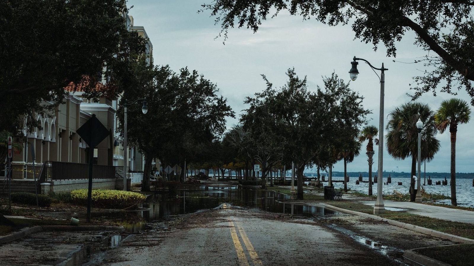
Ask any longtime Metro Manila resident what to check before buying a home and flooding comes up before price. The metro sits on a floodplain between a large lake and the sea, carries three major river systems, and gets hit by a wet season that seems to grow heavier every year. Two properties a few streets apart can have completely different flood stories, and the difference shows up in resale value, insurance, and how you live from June to November.
This guide maps the broad flood picture area by area, explains why elevation is only half the story, and shows you how to check a specific street before you commit. It describes general patterns, not a verdict on any specific property: always verify the exact address.
Why Metro Manila floods
Three forces stack on top of each other. The metro's rivers, the Pasig, the Marikina and the Tullahan, drain a huge watershed through dense city. Laguna de Bay to the southeast rises slowly after sustained rains and keeps lakeside districts wet for weeks. And in the oldest districts the drainage was built for a much smaller city, so even a strong afternoon downpour can turn intersections into pools. Typhoon season concentrates all three problems into a few brutal weeks.
The broad map: lower risk and higher risk areas
Generally more flood-resilient. The high ground runs along the metro's spine and its eastern and southern edges. Much of Quezon City sits on elevated terrain, especially the areas around the Diliman ridge. Makati's central business district and the Ayala side drain comparatively well. Bonifacio Global City in Taguig was master planned recently with modern drainage and sits on former base land. Parts of Muntinlupa and Las Piñas away from the lake and creeks, and the Antipolo and upper Rizal foothills east of the metro, sit well above flood level, which is part of their appeal to families.
Historically more flood-prone. The Marikina River valley carries the metro's most famous flood history, felt hardest along the riverside barangays of Marikina and the low sections of Cainta and Pasig near the river. The KAMANAVA belt (Caloocan, Malabon, Navotas, Valenzuela) deals with tidal flooding and slow drainage. The old districts of Manila around España, Sampaloc, Quiapo and Taft flood fast in heavy rain. Lakeside and creekside pockets of Taguig, Pasay near the bay reclamation edges, and low sections of Parañaque and Cavite's coastal corridor need street-level checking.
The key nuance: these are patterns, not sentences. Marikina has high, dry neighborhoods; Quezon City has creekside streets that pool. The metro floods street by street, which is why you check the address, not the city.
How to check a specific property
- Look up the official hazard maps. Project NOAH and the local government's own flood hazard maps show modeled flood depth by area for different rain scenarios. Ten minutes on them beats any seller's assurance.
- Ask the neighbors, not the seller. The question that unlocks everything: how high did the water get here during the last two or three strong typhoons, and how fast did it drain?
- Read the building. In flood-aware neighborhoods, houses sit on raised pads, garages step up from the street, and older homes have visible waterline stains. A ground floor built a meter above the road is telling you something.
- Check the street, the creek and the pumping station. Distance to the nearest waterway, the state of the drainage, and whether the barangay floods from rain or from river overflow all change the risk profile.
- For condos, think parking and access. Upper floor units do not get wet, but basement parking, lobbies and the streets around the tower do. Ask the building how the last big storm went.
What flooding does to value
Flood history is one of the quiet forces in Metro Manila pricing. It is part of why elevated districts command a premium per square meter, why the same developer prices similar towers differently across the metro, and why some bargains are cheap for a reason. If a listing looks far below its area's going rate, check the flood story before celebrating; our price per square meter tool tells you what the area norm is, and a big discount from it deserves an explanation.
The same logic applies to the metro's other big natural risk. Our guide to earthquake risk and the West Valley Fault covers the fault-line side of due diligence, and together the two checks take less than an hour for any address.
The bottom line
Do not cross a city off your list because of its reputation, and do not trust a street because of its address. Check the hazard maps, ask the neighbors, read the building, and price the risk like the market does. When you are ready to compare specific homes, browse the current listings for sale and put every candidate through the same two checks: water and fault line first, everything else after. This is general information based on public hazard patterns, not an assessment of any specific property; verify the exact address with official hazard maps and local sources before you transact.
Frequently asked questions
Which areas of Metro Manila are flood-safe?
The higher ground runs along the metro's spine and edges: much of Quezon City's elevated terrain, Makati's central business district, the master planned BGC in Taguig, parts of Muntinlupa and Las Piñas away from the lake, and the Antipolo foothills east of the metro. Even in these areas, individual creekside streets can pool, so always check the exact address.
Which areas of Metro Manila flood the most?
The Marikina River valley carries the most famous flood history, felt along riverside Marikina and low Cainta and Pasig; the KAMANAVA belt of Caloocan, Malabon, Navotas and Valenzuela deals with tidal flooding; and the old Manila districts around España, Sampaloc and Taft flood fast in heavy rain. These are patterns, not verdicts: the metro floods street by street.
How do I check if a specific property floods?
Look up the address on official hazard maps like Project NOAH and the local government's flood maps, then ask the neighbors how high the water got in the last strong typhoons and how fast it drained. Read the building too: raised ground floors and waterline stains tell the real story.
Does flood risk affect property prices?
Yes, quietly but consistently. Elevated, well-drained districts command a premium per square meter, and listings priced far below their area's going rate often have a flood story behind the discount. Check any suspicious bargain against the area norm before celebrating.
Browse properties on BalayHub
See all listings →
Read next
Condo Association Dues in the Philippines, Explained (2026)
What condo dues pay for, how they are computed per square meter (roughly ₱60 to ₱150 in most towers), what a real unit pays per month, special assessments, and what happens if an owner stops paying.
Apartment vs Condo in the Philippines: What Is the Difference?
The real difference between an apartment and a condo in the Philippines: ownership, dues, amenities and cost, which one to rent, and why buying almost always means a condo.
Renting Out Your Condo in the Philippines: the Landlord's Guide
How to turn a condo into rental income: building rules, pricing to the market, the lease contract done right, the BIR side of rental income, tenant screening, and managing from abroad.